

The great thing about land is that no matter what may happen to the structures on it, the land is always there. A structure can be torn down and a new one built. With home ownership, we usually take this for granted. However, there are locations in which this may not always be the case! For instance, properties with lake frontage along Lake Erie, or other areas of the country in which erosion from natural causes is an issue.
How much money would you pay to keep your lot the same size?
Last month, I appraised a property with Lake Erie frontage. It was for a private client. I thought that you might find this information interesting and possibly helpful.
WHO OWNS THE LAND ONCE IT FALLS INTO LAKE ERIE?
According to Ohio law, the State owns the land up to the natural high water mark. That means that once a property’s land erodes into the lake, the ownership of that portion of land shifts to the state. The owner will never get that land back. That means a loss of land and ultimately a loss of value for the home owner. The Ohio Department of Natural Resources (click on link) has a website at www.coastal.ohiodnr.gov, which has a lot of very helpful information regarding this situation!
In it you will also find the “Ohio’s Coastal Erosion Areas Preliminary 2018 Update” brochure.
Ohio’s Coastal Erosion Areas Prelim 2018 Update (Click on to download)
What is the erosion rate on Lake Erie? It is always changing. It really depends on many factors such as lake water levels, the weather and the composition of the soil. According to the Ohio Department of Natural Resources, erosion rates have been measured as high as 110′ per year. That’s the extreme, not the norm. None the less, that’s a sobering thought!
DESIGNATED EROSION CONTROL AREAS
Since 1988, the State of Ohio’s Department of Natural Resources, regularly measures the rate of erosion using numerous tools including aerial imagery and LiDAR as well as other mathematical calculations. LiDAR is a surveying technology that measures distance by illuminating a target with a laser light. According to the above noted Q & A brochure, the erosion rate is “measured by determining how far landward the bluff or bank has moved over time”. If a property’s erosion is estimated to be at a rate in which the property would be “lost by Lake Erie-related erosion within a thirty-year period”, it is designated as being in a Coastal Erosion Area. (CEA)
The aforementioned website also provides a satellite map that reflects which lots are in these designated areas. They are designated in red. (See a sample of the map below). This obviously needs to be disclosed when a home is being sold. This is a lending issue if the property being lent on has the potential of being gone within 30 years, which is the term for many residential loans.
Furthermore, special permits will need to be obtained if a land owner wants to build a permanent structure on land with this designation.

In comparing comparable sales in the neighborhood of the home I was appraising, my research reflected that comparable homes within a CEA sold for approx. 20% less than those not in a CEA. That is based upon a specific neighborhood and a specific type of home. The market impact might be different depending upon differing factors.
Needless to say, being in this situation does have a major negative impact on market value and marketability.
EROSION CONTROL MEASURES
Erosion control systems are very expensive. Of course, if the problem is not corrected, loosing land will be more expensive over time than taking steps to slow down the erosion. Some of the contracts for anti-erosion systems, that I have read, price the cost to be around $1,300-$1,375 per linear foot.
A home owner should do their research before choosing the type of control system they want to set in place. The pictures below are of a break wall that was put in place to slow down erosion. The home owner stated that this style of wall not only failed to stop the erosion, but actually increased it. How so? When the waves hit this type of wall, it actually launch the water up towards the cliff at an angle that actually increased erosion.


You can see what the results of erosion looks like below.

LOT SHAPES
The shape of a lot can be something to think about also. For instance, which lot looks more desirable of the two below? The one with the larger lake frontage on the right , or the one on the left with a very small portion of lake frontage? Of course, most would probably say the lot on the right since it offers more lake frontage. Keep in mind that there is a cost that comes with that frontage! If these lots are in the CEA ,$1,300 per linear foot can add up quickly.
Here’s something else to think about. Since the shape of the lot on the right is triangular, with each inch of erosion that takes place, more of the lot is disappearing at a faster rate than the lot on the left.
The interesting thing about the lot on the left is that it also has fantastic views of Lake Erie, like the lot on the right. However, it has a lot less lake frontage to worry about in terms of erosion. So, while the lot on the left is less desirable in terms of lake frontage, it is more desirable in terms of having less land area to have to be concerned about, when it comes to erosion.
Another thing to consider is the shape of the neighbor’s lots. If the adjacent neighbor’s lots are not protected from erosion, that may affect surrounding lots in a negative way.
These are just some things that an appraiser has to consider when it comes to valuation.


Sometimes it’s difficult to really appreciate the power of erosion since it happens over time. Here is a time-lapse video from Bawdsey, Suffolk, UK, which nicely demonstrates the power of erosion over time.
So if you are fortunate (or unfortunate) enough to own a property with fantastic Lake Erie views and frontage, or are considering buying a property that offers Lake Erie frontage, hopefully you found this information to be helpful!
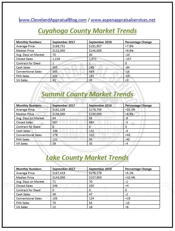
Here is my County Market Update comparing September 2017’s numbers with September 2018. I hope you find it useful! You can find more at www.aspenappraisalservices.net


Appraiser Fest is 14 days away! Officially two weeks!
There many awesome appraisers across the country that will be at this event. I am looking forward to meeting all of you at the Appraiser Fest. I am also looking forward to the excellent education and new appraisal tools we will learn about that can help us make our businesses a continued success! Safe travels to all who will be there!
Here are some other articles and videos I enjoyed this week! I hope you will also…
The Housing Market is as “Solid as Sears” – Housing Notes by Jonathan Miller
Would you be ready if the market did change? Sacramento Appraisal Blog
You’re In The Wrong Biz! – The Real Value Podcast
Five Quick Tips For Agents When Communicating With The Appraiser – Birmingham Appraisal Blog
Acreage Property Roads – What to Consider? – Advantage Appraisals
Appraiser Competency For Relocation Appraisals – RAC Blog (Written by Rachel Massey)
Get By With A Little Help From Our Friends – Ann Arbor Appraisal Blog
How to Handle Angry Borrowers and Agents – The Appraisal Coach
What is “Evidence Based Valuation”? – George Dell’s Analogue Blog
AI Damaging the Livelihood of Appraisers – Appraiser Blogs (Jonathan Miller Author)
The Best Real Estate Podcasts – DW Slater Company Appraisal Blog
Appraiser Fest – Valuation Nation
Discover more from Cleveland Appraisal Blog
Subscribe to get the latest posts sent to your email.
Wow Jamie. This was really interesting and sobering. It’s unreal to see the erosion factor influencing value by that much, but I get it. I wonder if lenders have a problem with this. I recall a property a few hours away from me listed for significantly less than the comps because there is an erosion problem. Cash buyer only is how it was advertised.
It is sobering! I have not appraised a property in this situation for a bank. I am sure that it would be a problem for a lender. My guess is that they would require that an anti-erosion system be put in place. The comparable sales that I looked at, that were in that CEA designation, appeared to have been financed. Hopefully the appraisers didn’t miss any of these homes being in the CEA or equally as bad, that they qualified for an appraisal waiver! Yikes!